Request a Quote
We make getting a quote for your project fast and easy. Click below and fill out our request a quote form. We will get back with you shortly.

Recent News
04/18/2023 - Event Management for Daytona Beach
Aimed at improving the regional mobility for Volusia County, the Event Management project deployed multiple technologies providing real-time capabilities for the monitoring and management of arterial corridors through dynamic wayfinding. Located at the nexus of Interstate 4 and Interstate 95, the Daytona Beach area experiences significant surges in traffic volumes from tourist driven seasonal peak periods and planned or unplanned regional events. Large-scale annual events result in massive upticks in traffic on the local roadways, including increases of upwards of 400% over normal volumes for events such as the Daytona 500 and Biketoberfest. With the occasional detour traffic circumventing road closures onadjacent interstates and heavy directional traffic to and from the area’s world-renowned beaches, the existing traffic management system failed to meet the needs of the Department or motoring public of the region.
|
News
Event Management for Daytona Beach
April 18, 2023
Florida Department of Transportation (FDOT) – District Five
Project Manager Noemi Bonilla-Rodriguez
Project Location Daytona Beach, Volusia County, Florida
Start Date May 30, 2019 Completion Date July 21, 2022
Project Cost $2,932,711 (total) – $513,136 (design); $2,021,183 (construction); $398,392 (CEI)
Aimed at improving the regional mobility for Volusia County, the Event Management project deployed multiple technologies providing real-time capabilities for the monitoring and management of arterial corridors through dynamic wayfinding. Located at the nexus of Interstate 4 and Interstate 95, the Daytona Beach area experiences significant surges in traffic volumes from tourist driven seasonal peak periods and planned or unplanned regional events. Large-scale annual events result in massive upticks in traffic on the local roadways, including increases of upwards of 400% over normal volumes for events such as the Daytona 500 and Biketoberfest. With the occasional detour traffic circumventing road closures onadjacent interstates and heavy directional traffic to and from the area’s world-renowned beaches, the existing traffic management system failed to meet the needs of the Department or motoring public of the region.
|
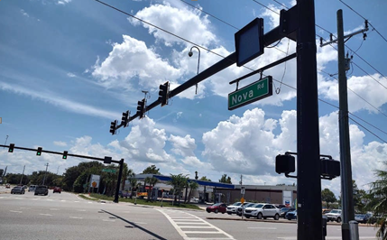
Supplementing the existing arterial management and traffic signalization systems, Atkins North America, Inc. deployed a standalone dynamic wayfinding system capable of providing turn-by-turn information to motorists through multi-phased blankout signs, dynamic message signs (DMS), and travel time sensors. Each blankout sign was installed at or in advance of key decision points (e.g., major signalized intersections) and capable of providing unique display messages in accordance with the currently active response plan. Sign displays were created to handle a variety of potential events, including ingress and egress to or from specific parking facilities for planned events (e.g., “LOT 7” at the Daytona 500), detours to and from adjacent interstate corridors for major incidents and road closures, and directional guidance for available beach parking. Providing control of the sign displays, web-enabled relay controllers were installed with connection to the Department’s fiber optic communications network allowing for remote management and control of the system. Full-matrix color DMS displays were installed on major arterial corridors in advance of the dynamic wayfinding system to alert motorists of real-time traffic and roadway conditions and to provide detailed information about special events. Strategic locations were selected for the deployment of travel time sensors using Bluetooth enabled MAC-address matching to determine current travel speed, travel time, and origin-destination information for the continued monitoring of traffic conditions. In total, the project implemented ten (10) major arterial and local roadway corridors, including US 1 (Yonge St), US 92 (International Speedway Blvd), SR 5A (Nova Rd), SR 40 (Granada Blvd), SR 400 (Beville Rd), SR 430 (Mason Ave), SR 483 (Clyde Morris Blvd), CR 4009 (Williamson Blvd), LPGA Blvd, and Midway Ave.
In order to manage the system, the project included the architecture and development of a customized control software accessible through a standard web browser interface (e.g., URL). The software provides a centralized platform for the
Department to monitor, manage, control, and operate the dynamic wayfinding system remotely empowering operational staff to enable or disable individual signs; alter the active display; create, modify, enable, or remove customized response plans; and more. The software also provides ability to verify the active display for each blankout sign using near real-time (e.g., every five seconds) snapshots from small-form verification cameras affixed directly to the sign housing. This feature solves an identified user need to verify the accuracy of active displays and ensure contradicting displays are not simultaneously active.
Provided as both an innovation and cost-savings, small-form verification cameras were implemented at each blankout sign directly affixed to the display housing using a customized mounting bracket. Each mounting bracket included an embedded junction box to house surge protection and communication equipment and was designed to provide the minimum necessary viewing angle to capture the entire display without creating additional structural moment or visual obstruction. Working with multiple vendors, the custom-designed small-form verification camera and bracket solution was developed to meet the system needs and manage overall cost with a comprehensive unit cost less than $1,000.
Innovation
- Successful deployment of region’s first dynamic wayfinding system providing turn-by-turn directional guidance for multiple endpoints and events (e.g., planned, unplanned, seasonal).
- Project developed a standalone custom software platform for the management, monitoring, control, and operation of the dynamic wayfinding system using a standard web browser interface. This platform provides the means for the Department and regional stakeholders to operate the system remotely and create, enable, and modify custom response plans covering the entire region.
- Customized software platform includes snapshot feature to capture near real-time (e.g., every five seconds) images of the active blankout sign display for remote verification of display accuracy. Utilizing snapshots instead of live video streams limits the required bandwidth and improves the reliability of the network and system.
- Project included the development of a custom-designed verification camera and mounting assembly to capture images of the active blankout sign display. The small-form verification camera setup was engineered to minimize the physical footprint of the camera and mounting hardware while using a wide-angled lens to provide the necessary field of view. Infrared technology was also implemented to eliminate “washout” from the active LEDs. Options for the small-form verification camera from other industries (e.g., security) were analyzed against the traditional technology offerings for traffic control applications to identify cost savings. The final selected product was not listed on the Department’s Approved Products List (APL) and was presented for review, testing, and approval on the basis of unique need and functionality.
Project Photos
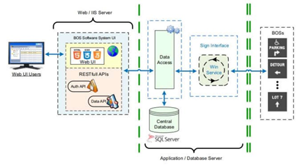
High-level data flow and architecture for the Event Management dynamic wayfinding system and centralized control software.
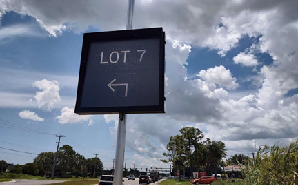
LED blankout signs were installed at signalized intersections to provide dynamic wayfinding for motorists during large events (e.g., Daytona 500), as well as recurring events like detours.
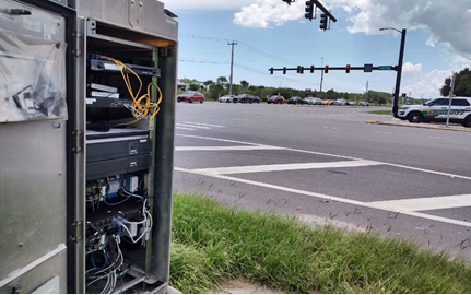
The dynamic wayfinding system includes a web-enabled relay system capable of remotely activating the appropriate message for up to ten displays each.

The project included a macro-view of the Daytona Beach roadway network to plan ingress and egress route decision points to determine where to place the elements of the dynamic wayfinding system ahead of large- scale events (e.g., Daytona 500, hurricane evacuation)
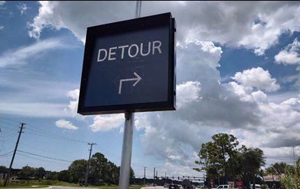
LED blankouts signs for the dynamic wayfinding system include multiple displays to accommodate a variety of scenarios and were installed at and in advance of signalized intersections.
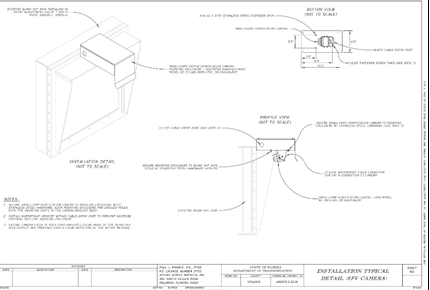
Working closely with Southern Manufacturing, Inc., a custom low- profile camera mounting assembly was designed to mount directly to the sign housing providing verification images of the current display to remote operators in real-time.
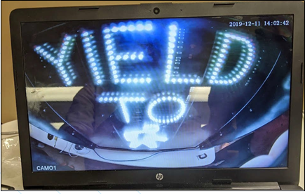
Deploying a wide-angle lens camera typically used in marine applications allowed for the system to provide real- time verification images of the current sign display to remote operators using the centralized software system.